disaster
Earthquake of magnitude 4.2 jolts Myanmar
Naypyidaw (Myanmar), March 29: An earthquake of magnitude 4.2 on the Richter Scale hit Myanmar on Friday at 11:56 pm (local time), according to the National Center for Seismology (NCS).
In a post on X, the National Center for Seismology wrote, “Earthquake of magnitude: 4.2, On: March 28, 2025, 23:56:29 IST, Latitude: 22.15 N, Longitude: 95.41 E, Depth: 10 Km, Location: Myanmar.”
As per the NCS, the latest earthquake occurred at a depth of 10 km, making it susceptible to aftershocks.
The NCS reported the earthquake was recorded at Latitude 22.15 N and Longitude 95.41 E.
Earlier on Friday, Myanmar was jolted by a series of tremors, including a major earthquake of magnitude 7.2 on the Richter Scale that occurred at 11:50 am (local time).
The powerful tremor was felt in Bangkok and several parts of Thailand, with eyewitness reports and local media accounts noting that hundreds of people rushed out of swaying buildings in Bangkok.
Several posts on social media showed water splashing out of swimming pools due to the quake’s intensity.
According to the NCS, the 7.2-magnitude earthquake struck at a depth of 10 km and was recorded at Latitude 21.93 N and Longitude 96.07 E.
In a post on X, NCS said, “Earthquake of Magnitude: 7.2, On: March 28, 2025, 11:50:52 IST, Latitude: 21.93 N, Longitude: 96.07 E, Depth: 10 Km, Location: Myanmar.”
The earthquake at around 11:50 a.m. IST was followed by an aftershock of 6.4-magnitude minutes later.
The NCS said that an earthquake of magnitude 4.9 on the Richter scale hit Myanmar, saying that it was the third aftershock, following the first 7.2 magnitude on the Richter scale.
Video obtained by CNN from Myanmar appeared to show a road bridge spanning the Irrawaddy River, which runs through Mandalay, collapsing into the river in a cloud of dust and water.
Shallow earthquakes like this one are more dangerous than deeper ones due to their greater energy release closer to the Earth’s surface, causing stronger ground shaking and increased damage to structures and casualties, compared to deeper earthquakes which lose energy as they travel to the surface.
Although Myanmar is an earthquake-prone country, there has not been proposed an official national seismic hazard map.
Due to the collision between the Eurasian and Indo-Australian plates, Myanmar is an area with a high seismic hazard level.
According to the earthquake parameters summarised by the International Seismological Centre around 140 events with magnitude greater than or equal to 3.0 have taken place in Myanmar and its vicinity every year from 1990 to 2019. Thus, it is evident that Myanmar is vulnerable to hazards from moderate and large magnitude earthquakes, including tsunami hazards along its long coastline.


Mumbai: A 53-year-old resident of Thane recently fell prey to scammers and lost Rs 39 lakh in a cryptocurrency investment fraud.
The scammers promised lucrative returns on trading and induced him to register on a bogus trading website and transfer money in over a dozen transactions.
The case dates back to June 26 last year, when he received a phone call from a person sharing information about the trading website, promising withdrawal of earnings by the end of every month.
Another scammer posed as a fund manager, inducing the man to invest. He could see his earnings on the website from June 26 till December 3, but when he asked for his returns, the scammers started giving evasive replies.
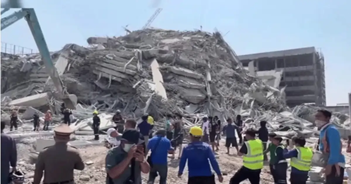
Ahmedabad, June 17: Four days after the devastating crash of Air India flight AI-171 en route from Ahmedabad to London, authorities have confirmed that 144 DNA samples have been successfully matched as of noon Tuesday, according to Gujarat Minister of State for Home, Harsh Sanghavi.
The identification process is being led by a combined team from the State Forensic Science Laboratory (FSL) and the National Forensic Sciences University, working around the clock to bring clarity to grieving families.
“This is a highly sensitive and emotional task. Every match is not just a technical confirmation, but a step toward giving closure to families waiting in anguish,” an official from the forensic unit said.
Emergency response teams remain stationed at the crash site in Meghaninagar, where investigators continue to recover personal belongings and body fragments amidst the wreckage.
Authorities have stated that all efforts are being made to ensure the dignity of the deceased and transparency in communication with the victims’ relatives.
Tata Group, which re-acquired Air India in 2022, has announced an ex gratia payment of Rs one crore to the families of each of the deceased from the AI‑171 crash near Ahmedabad. In addition, Air India has immediately released an interim relief payout of Rs 25 lakh per family — and to the lone survivor — to cover urgent needs.
The group will also cover all medical expenses for the injured and pledged financial support for rebuilding a damaged hostel at BJ Medical College. Chairman N. Chandrasekaran described it as “one of the darkest days in the Tata Group’s history.”
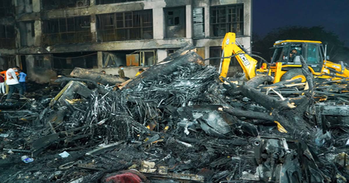
As of June 17, rescue and recovery efforts at the Ahmedabad crash site of Air India flight AI-171 remain intense and deeply coordinated. Over 300 firefighters, supported by 60 fire vehicles and 20 water bowsers from Ahmedabad, Gandhinagar, Vadodara, ONGC, and other nearby agencies, continue to clear debris and extinguish smouldering wreckage.
On the ground, three NDRF teams, 150 CRPF officers, Indian Army personnel, and teams from the CISF, BSF, and Western Railway Disaster Management are conducting systematic searches for remains and missing belongings.
Specialised sniffer dogs are aiding in the recovery of human remains, while Ahmedabad Police, responding to disturbing reports, have deployed animal rescue teams to safely relocate stray dogs scavenging at the crash site.
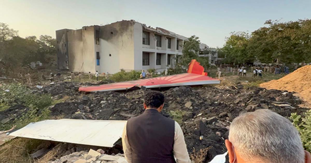
Ahmedabad, June 16: After the second black box, which is a critical component in determining the cause of the crash, was recovered, the investigators have intensified the probe in the Air India crash case.
The Cockpit Voice Recorder (CVR), commonly referred to as the second black box, was retrieved from the cockpit section of the wreckage.
This comes days after the Flight Data Recorder (FDR) was recovered from the tail end of the aircraft. The Cockpit Voice Recorder (CVR) captures all audio inside the cockpit, including conversations between pilots, radio transmissions, alarm sounds, and any background noise in the final moments before a crash.
It is a crucial tool for investigators, as it helps reconstruct the crew’s decision-making, identify possible human errors or mechanical warnings, and determine the sequence of events that led to an aviation incident.
Officials from the Aircraft Accident Investigation Bureau (AAIB) confirmed the findings, noting that both devices are in the process of being analysed. The CVR is expected to provide crucial insights into the final moments of the flight, including pilot communication and cockpit sounds, which may help investigators piece together the chain of events leading up to the tragedy.
The recovery was also acknowledged by P.K. Mishra, Principal Secretary to Prime Minister Narendra Modi, who visited the crash site on Sunday. During his visit, he reviewed ongoing investigation efforts and later went to the Civil Hospital, where injured passengers and local residents are being treated.
The death toll from the catastrophic Air India crash in Meghaninagar has risen to 270, officials have said. Among the deceased are 241 passengers who were on board the ill-fated flight, as well as several others who were present in nearby hostels, mess halls, and the surrounding residential area when the aircraft went down.
Meanwhile, the Gujarat government has declared a one-day state mourning on Monday in the state as a mark of respect to former Chief Minister Vijay Rupani, who lost his life in the Air India plane crash in Ahmedabad on June 12. All official functions and celebrations will remain suspended during the mourning period, and the national flag will be flown at half-mast across government buildings.

UAE Restricts Entry and Transit for Iranian Passport Holders Amid Rising Regional Tensions

Mumbai Traffic Police takes action against self-styled VIP, seizes lights and sirens of 8 vehicles, recommends cancellation of registration by Traffic Department

Mayor Ritu Tawde: The burden of patient services on Rajawadi Hospital in Ghatkopar is high, delays in the reconstruction work of the hospital will not be tolerated

Water Crisis Alert In Vasai Virar, Week Long Supply Disruption From April 4

Jain temple theft suspect arrested from Madhya Pradesh in Kala Chowki area, police arrested the thief from Madhya Pradesh and brought him to Mumbai

Married Mumbai Woman Mocked In Andheri Society Over ‘Lift Kissing’ CCTV Video, Files Police Complaint

LPG Crisis In Maharashtra: Cyber Crime On Rise Amid Shortage, 2 Women Lose ₹4 Lakh In ‘Gas Update’ Online Scam In Kalyan-Dombivli

Mahayoti’s big gift to the people of Mumbai… Now there is no tax for houses up to 500 square feet, the Municipal Corporation has increased this limit to 700 square feet.

Dhurandhar 2 Box Office Collection Day 1: Ranveer Singh Starrer Takes An Exceptional Opening; Crosses ₹100 Crore Mark

Govandi ISIS propaganda case: Ayan arrested… Anjuman-e-Islam Kalsekar College also on the radar, how did the second student come into contact with ISIS, investigation underway
-

 Crime4 years ago
Class 10 student jumps to death in Jaipur
-

 Maharashtra1 year ago
Mumbai Local Train Update: Central Railway’s New Timetable Comes Into Effect; Check Full List Of Revised Timings & Stations
-

 Maharashtra1 year ago
Mumbai To Go Toll-Free Tonight! Maharashtra Govt Announces Complete Toll Waiver For Light Motor Vehicles At All 5 Entry Points Of City
-

 Maharashtra2 years ago
False photo of Imtiaz Jaleel’s rally, exposing the fooling conspiracy
-

 National News1 year ago
Ministry of Railways rolls out Special Drive 4.0 with focus on digitisation, cleanliness, inclusiveness and grievance redressal
-

 Maharashtra1 year ago
Maharashtra Elections 2024: Mumbai Metro & BEST Services Extended Till Midnight On Voting Day
-

 National News2 years ago
J&K: 4 Jawans Killed, 28 Injured After Bus Carrying BSF Personnel For Poll Duty Falls Into Gorge In Budgam; Terrifying Visuals Surface
-

 Crime1 year ago
Baba Siddique Murder: Mumbai Police Unable To Get Lawrence Bishnoi Custody Due To Home Ministry Order, Says Report